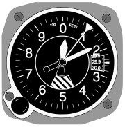
An altimeter is an instrument used to measure the altitude of an object above a fixed level. The measurement of altitude is called altimetry, which is related to the term bathymetry, the measurement of depth underwater.
Aircraft Instrumentation
Pressure altimeter
A pressure altimeter (also called barometric altimeter) is the altimeter found in most aircraft. In it, an aneroid barometer measures the atmospheric pressure from a static port outside the aircraft. Air pressure decreases with an increase of altitude—approximately 100 millibars per 800 meters or one inch of mercury per 1000 feet near sea level.
The altimeter is calibrated to show the pressure directly as an altitude above mean sea level, in accordance with a mathematical model defined by the International Standard Atmosphere (ISA). Older aircraft used a simple aneroid barometer where the needle made less than one revolution around the face from zero to full scale. Modern aircraft use a "sensitive altimeter" which has a primary needle that makes multiple revolutions, and one or more secondary needles that show the number of revolutions, similar to a clock face. In other words, each needle points to a different digit of the current altitude measurement.
On a sensitive altimeter, the sea level reference pressure can be adjusted by a setting knob. The reference pressure, in inches of mercury in Canada and the US and millibars (or hectopascals) elsewhere, is displayed in the Kollsman Window, visible at the right side of the aircraft altimeter shown here. This is necessary, since sea level reference atmospheric pressure varies with temperature and the movement of pressure systems in the atmosphere.
In aviation terminology, the regional or local air pressure at mean sea level (MSL) is called the QNH or "altimeter setting", and the pressure which will calibrate the altimeter to show the height above ground at a given airfield is called the QFE of the field. An altimeter cannot, however, be adjusted for variations in air temperature. Differences in temperature from the ISA model will, therefore, cause errors in indicated altitude.

The calibration formula for an altimeter, up to 36,090 feet (11,000 m), can be written as:
where h is the indicated altitude in feet, P is the static pressure and Pref is the reference pressure (use same units for both). This is derived from the barometric formula using the scale height for the troposphere.
Radar altimeter
A radar altimeter measures altitude more directly, using the time taken for a radio signal to reflect from the surface back to the aircraft. The radar altimeter is used to measure height above ground level during landing in commercial and military aircraft. Radar altimeters are also a component of terrain avoidance warning systems, warning the pilot if the aircraft is flying too low, or if there is rising terrain ahead. Radar altimeter technology is also used in terrain-following radar allowing fighter aircraft to fly at very low altitude.
Global Positioning System
Global Positioning System (GPS) receivers can also determine altitude by trilateration with four or more satellites. However, altitude determined using autonomous GPS is not precise or accurate enough to supersede the pressure altimeter for aviation use without using some method of augmentation.
Other Modes of Transport
The altimeter is an instrument optional in off-road vehicles to aid in navigation. Some high-performance luxury cars which were never intended to leave paved roads, such as the Duesenberg in the 1930s, have also been equipped with an altimeter.
Mountaineers use wrist-mounted barometric altimeters when on high-altitude expeditions, as do skydivers.
Measuring air pressure
The local atmospheric pressure or ambient pressure is displayed in the Kollsman window of a sensitive altimeter, when it is adjusted to read zero altitude.[1].
Satellites
A number of satellites (see links) use advanced dual-band radar altimeters to measure height from a spacecraft. That measurement, coupled with orbital elements (possibly augmented by GPS), enables determination of the terrain. The two different wavelengths of radio waves used permit the altimeter to automatically correct for varying delays in the ionosphere.
Over water, detailed satellite altitude information has proven useful. Humps in the water indicate gravitational concentrations, permitting a computer program to construct a map of undersea features such as mountains. The altimeters can also measure wave heights, wave directions, and wave spectra. This information permits computer programs to measure the speed of ocean currents and produce detailed maps of wind speeds and directions at the surface, even in extremely stormy conditions.
See also
- Flight instruments
- Flight level
- seasat, TOPEX/Poseidon are satellites that deployed extremely accurate altimeters
- United Airlines Flight 389
- Jason-1, Ocean Surface Topography Mission/Jason-2 are current satellite missions that use altimeters to measure sea surface height


No comments:
Post a Comment